Monday, October 4, 2021

ZION BRYCE GRAND CANYON DAY 8 – EIGHT STRAIGHT (DOWN)


This trip has afforded us the opportunity to hike some of the most iconic trails in the USA.  Trails that attract people from around the globe and have done so for many decades.  Today, on our last of 8 straight days of hiking, we will attempt the most dramatic hike of our trip, the Kaibab Trail.  By the numbers, it’s similar to yesterday’s trek, 6 miles roundtrip and dropping 2200 feet below the rim of the Grand Canyon.  But it’s different, too.  The trail has very steep grades followed by relatively long flats, so we will get further towards the middle of the canyon, but the return will be more punishing.  Yesterday from Bright Angel Lookout, we were able to get a great photo of today’s trail.

We’re out early, but not as early as yesterday.  It rained a bit last night and the remaining cloud cover will be our friend today.  The wind when we start down the trail, not so much, blowing the fine sand into our eyes and mouths.  Fortunately, the wind subsided within the initial few hundred feet of elevation drop.  Just under a mile and we get to the aptly named Ooo-Ahh point (who said the 19th century miners didn’t have a sense of humor?)  Instagram was pretty much invented for selfies here. 


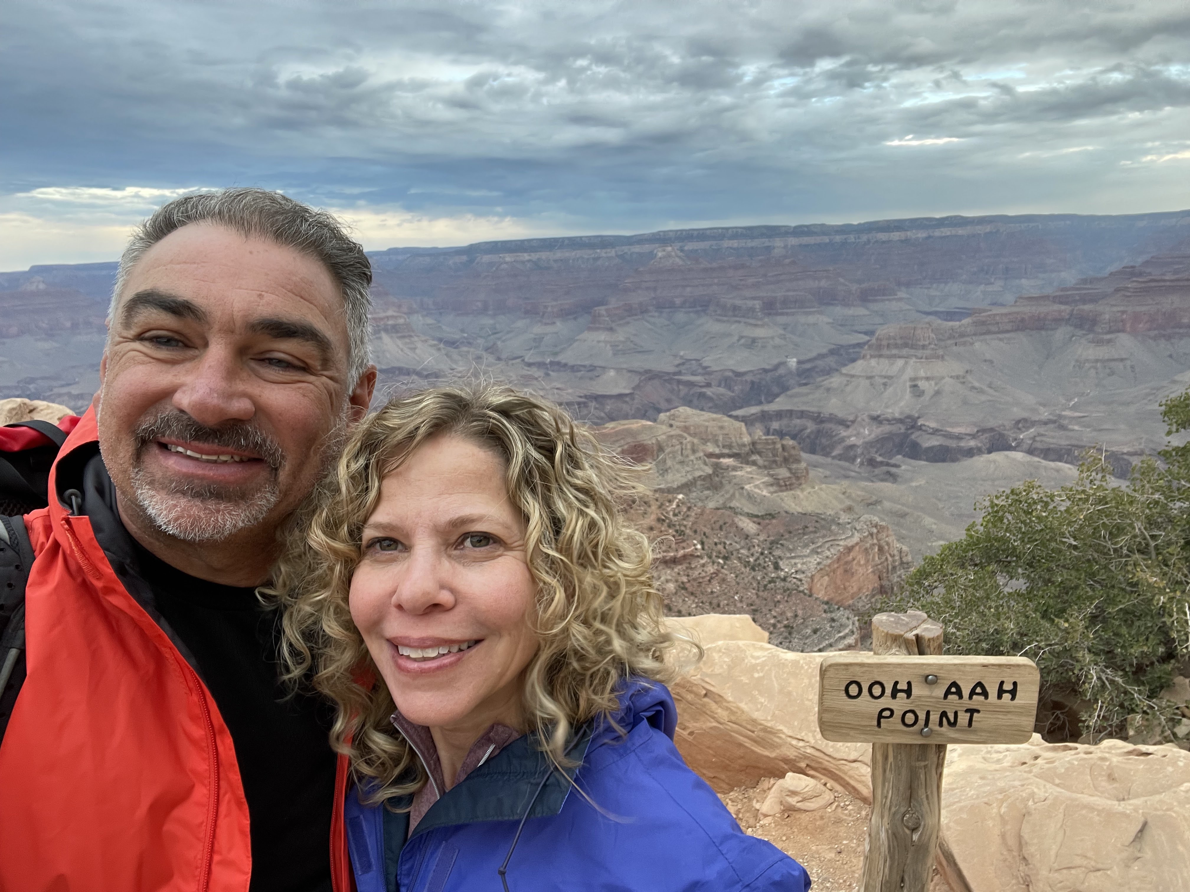
When our oohing and aahing subsides, we continue on to the first narrow ridgeback, about 2 feet wide along this section’s top spine with steep drop-offs on either side and sweeping 270 degree views.  It’s exactly what you hope for when you think hiking.  We’re taking in the enormity of the scene while doing our best to not lose focus and accidently step into thin air.


Another steep decline and we reach the 2nd ridgeback at Cedar Point, half the way down now.  It’s just as exciting to traverse as the first and even more picturesque.   Across the ridge, the trail circles the peak we have been approaching this whole time.  Around the other side, we arrive at Skeleton Point, marked by a carved wooden sign and our furthest point out today.   Thanks to a chatty hiker we met along the way, we know to duck left behind the unmarked donkey hitching post.  Just as our momentary friend advised, we are rewarded with the most amazing views of the Colorado River we will have during this trip.  There are three flat tiers like stadium seating and a few people scattered about, all snacking, resting and generally appreciating our place in time. 


We start our way back up.  Today is mentally easier because we’re not worried about sun and pretty much know what to expect from the trails.  We’re better equipped to absorb what we’re seeing and notice how oddly lush the landscape is here.  Our expectations were rocks, dirt and dust, but a wide variety of flora has figured out how to make this place home, dense arrangements of yellows and greens with the occasional accent splash of tiny, brightly colored flowers.  We take special notice of the tall, skinny seed pod plants with the base that looks like banana yellow aloe.  If there’s a bit of soil and even a hint of water, there is a plant that will figure out how to survive there.


We make it back to Cedar Point and stop for lunch, or whatever you call a chicken Ceasar wrap and an orange eaten at 9:45am.  There is no potable water along this trail (or any water for that matter) so we’re hydrating but rationing and rationalizing some.  Water is heavy, like fuel on an airplane, so like that fuel, you calculate, add a safety factor and decide how much to bring before you take off.  But any pilot will tell you that every flight is running out of fuel at all times.  We push a few yards back past OohAhh, now crowded with picture takers, and set our sights on the final ascent of the trip.  We apparently saved the steepest switchbacks for last, when we’re most tired, most sore.  Great planning.  We finish our last sips of water as we broach the canyon rim, feeling like Rocky finally making the top of the Art Museum steps, triumphant horn section music playing in our heads. 


It’s only 11am and there’s still plenty of park we want to see, so we drive up to The Village and the start of Hermit Road, the shuttle-access only lane with 9 scenic overlooks.  Just as we get to the start of the line, we hear the clang-clang-clang of the crossing bells and we watch the approach of the fabled Grand Canyon Railway train, historic locomotives and passenger cars smartly dressed in the line’s silver and yellow livery that looks as close to my childhood HO train set as I could have ever hoped for.

We have the DSLR and are hoping for one more photo get – the elusive California Condor.  We score at our very first stop, Maricopa Point, a big specimen preening in the noon sunshine.  The bus driver has never even seen one live before, throws the shuttle into park and joins us for a look.  The big 400mm lens is at its limits trying to reach the bird on the far-away cliffside and we can get a few grainy pix, so mostly we just use the camera as a telescope and watch the creature being him (or her, it’s hard to tell) self. 

We get a bit of rain during lunch, the first and only precipitation we’ve seen on the entire trip.  The light shower passes quickly and is gone before as we get back to the Village.  This time we’re here to see the legendary El Tovar Hotel, the crown jewel of the historic National Park lodges.  Designed by Charles Whittlesey as a mash up between a Swiss chalet and Norwegian villa, it was considered the most elegant hotel west of the Mississippi when it opened in 1905.  The lobby is festooned with huge taxidermy mounts, elk and ram and buffalo, a reminder of the days when every gentleman of means had a trophy room of his own and his wife was cool using big, smelly, dusty animals as décor. 

Shower and well-deserved nap.  We head back into the park for sunset and choose Mather Point, close to the Visitor’s Center parking lot.  At first, we’re disappointed that we’re not going to actually see the sunset, the horizon obscured by the tall pine trees.  We stay because I’m here, Mandy’s here, the Grand Canyon’s here, and we’re glad we did.  Turns out that here, the sunset isn’t so much about the sunset, but what the sunset does to the rocks and valleys.  As many times as we promised ourselves we were done taking pictures of rocks, here we are, taking dozens more.  It’s why our grandparents and parents and we come here.  It’s why our children will bring their children and grandchildren here.  It just doesn’t get old.


Tuesday, September 28, 2021

ZION BRYCE GRAND CANYON DAY 7 – THE ELUSIVE IMAGE

"There will never be a photograph of the Grand Canyon that can adequately describe its depth, breadth, and true beauty."  Stefanie Payne

“But we’re damn sure gonna try”  Pasquale Onofrio

We’re out early and headed into the park.  The Grand Canyon is an “upside down” park.  At Zion, we did traditional hiking, start at the floor of the valley and climb up the mountain.  Here everything starts at the top and goes downhill from there, so strategy is different.  Today’s plan is Bright Angel Trail, a steep trek into the canyon that has been walked by Native Americans, pioneers, early miners, and many of our parents and grandparents.  We’re covering a 6 mile out-and-back, down-then-up that will drop us over 2000 feet below the rim.  The early fall forecast is saying hot-n-sunny, and as the air sinks into the lower elevations it gets compressed, releasing heat as energy, so it will be 20-30 degrees hotter at the bottom.  Hence we’re up and out at zero-dark-thirty.  First light is beautiful, haze in the valley, the moon hanging low in the cloudless blue sky. 


The trail is serious, as emphasized by the stern warning signs provided by the National Park Service.  It’s very easy overestimate your conditioning and overextend on the way in, then underestimate the weather conditions and your provisions on the way back up.  Along the way, several signs remind you that “down is optional, up is mandatory.”  The fun of being our age is that we know good advice when we hear it, so even though our goal is the 3-Mile Resthouse and back, we’re OK turning around at any point if things get too hairy. 

We’re barely through the first set of switchbacks when out of nowhere a male Bighorn Mountain Sheep – 1 of 2 just rams in the area – strolls by us, just a fellow hiker passing on the trail close enough to high five. 


It’s quiet on the way down, despite being a busy Saturday.  It’s really nice to feel like you have the place to yourself on a trail, even if just for 15 minutes.  We take pictures as the light changes, shadows forced back, giving way to deep colors.  We get through the two “tunnels”, doorways in the rock really, and to the 1.5 Mile Resthouse relatively easily, so after a quick break we decide to push on. 


Sure, gravity does most of the hard work this way, but it’s taking a toll on our knees, so we step carefully, looking for grades rather than tall steps.  We’re at the 3-Mile Resthouse, feel good and discuss pushing on to Indian Garden another mile-and-a-half away and another 2000 feet down.  Common sense (and the damned effective picture of the puking dude on that sign) kicks in and we start our way back.  500 feet up, and we’re winded already.  The sun, on the way down our photo buddy, is now a giant looming rival in our (admittedly slow) footrace back to the top before we’re caught in the punishing direct rays. 


It’s the most difficult ascent we have attempted on this trip, and we conjure some of our tried-and-true strategies.  We break our remaining journey into “units”, fifteen-minute segments that we count down.  “Seven units left.”  We pace, we breathe the thin air, break for a few sips of water and carry on.  “Six units left, we got this!”  We take stock of our weary selves.  Head ok.  Neck, arms, shoulders, check, check, check.  Back, bit tired from the pack, but not bad.  Knees, bit sore, so watch.  Ankles and feet, surprisingly OK.  “Five units left.”  And there are still some great pictures to be had.  


Around 8:45 we pass a donkey train headed down, cowgirl guide in the front, visitors in the middle, cowboy guide in the back, everyone smiling, chatty.  Maybe the Brady’s were right.  Maybe we’re doing this wrong.


At 9am we’re in full sun, the rim and nearby peaks no longer providing any hiding places.  We’re splitting our last bottle of water, and can see the goal line.  Unfortunately, it’s just past that last steep set of switchbacks. 


We make the top with a big sigh and great feeling of accomplishment.  Although this is the most popular National Park in the country, less than five percent of the six-and-a-half million annual visitors venture below the rim.  We take pride in the fact that at 55 (and Mandy’s advanced age of three days older than me!) we’re still up for some rewarding challenges.

Beeline to the room to shower the dust and salt off, then out to lunch.  Another not-a-foodie town and none of the restaurants near the hotel offer anything inspiring.  Back in the park we go to the Yavapai Tavern for the Melted Elk, a well dressed elk burger, Baja Chicken Enchilada Soup and some good local beer.  It’s as nice a menu as we have ever seen inside a National Park, and it’s a very well done upgrade from the old 1970s cafeterias. 

Despite having hiked 6 miles this morning, we have seen just a fraction of a fraction the Canyon.  One of the best features of the park is the accessibility.  There are dozens of great viewpoints just a few steps from your parked car, and that’s about all that’s left in our tank today.  Driving to the first spot, we stop to visit with a pair of young elk, a cow and a young bull that still has velvet on his antlers.  Just a mile up the road is daddy, majestic, right out of the Hartford commercial, although this has turned into more of a Mutual of Omaha Wild Kingdom episode.  We lean in, whispering and trying different angles, trying to make Marlin Perkins proud of our work.


We finally make Lipan Point, almost to the East Entrance.  It’s the best view of the canyon yet, but we’re still surprised that we see so little of the Colorado river.  The river is at the bottom of a narrow V inside of a much wider V, so seeing the fast moving water is akin to finding Waldo.  We stop at several more vantage points, each time unable to fully understand at the sheer breadth of all we are seeing, each time realizing how little of it we will ever see, each time trying for that elusive photograph that captures even what our own live experience cannot.


Jump cut to dinner.  Big E Steakhouse & Saloon, Grand Canyon, Arizona.  Middle Americana at it’s middle of the road truest.  My T-Bone sports an embossed stick to let me know it’s prepared to the perfect medium rare as ordered, the Dark Horse Central Coast Cab just the right compliment to both my beef and Mandy’s poultry.


BATH, CINQUE TERRE AND SARDINIA DAY 12 – BEAUTIFUL PEOPLE, BEAUTIFUL PLACES

  It’s a hiking day, and we’re dressed for it.  But we’re not dressed for breakfast at Hotel Cala di Volpe.  It’s Vuitton to open and the mo...